top of page

Mastering Drone LiDAR Scanning with ROCK R3 Pro & DJI M300
Explore the process of flying the R3 Pro LiDAR scanner to map buildings using the DJI M300 drone.
3 min read
389


Planimetric Linework Surveying Deliverables with ROCK Pro Services
With the ROCK 50 Plan as your foundation, you can harness the power of ROCK Pro Services to order detailed planimetric deliverables.
3 min read
517


ROCK Pro Services: Get Professional & Accurate Surveying Deliverables
ROCK Processing Services empowers your team to deliver complex project deliverables with expert precision and at competive prices.
3 min read
400


ROCK SLAM LiDAR with the R3 Pro: A Comprehensive Guide
In this article, we'll delve into how to operate the R3 Pro with SLAM mode and share some valuable tips on capturing high-quality data.
2 min read
1,292


Case Study: Drone Services Provider Navigates a 2,500-Acre Gold Mine Site in Fiji with ROCK LiDAR
Kahuto Pacific was hired by a Canadian mining company to provide topographic, aerial LiDAR for a 2,500-acre (1,000-hectare) property.
5 min read
1,939


GCP Best Practices for Aerial Surveying Projects
Ground Control Points (GCPs) are a crucial part of aerial surveying. They help make sure the data collected is as precise as possible.
3 min read
893


Case Study: Construction Company Saves $300k by Updating Contours with ROCK Cloud
Here's the top-level takeaway: Companies and contractors can save a significant amount of money in Construction and Earthworks projects.
4 min read
560


Case Study: 25 Acres of LiDAR Data Captured (and Delivered) in Under 48 Hours
Do you ever find yourself in a time crunch? When it comes to last-second client projects, it's easy for panic to begin to settle in. But,...
3 min read
917


3 Types of Contours — Which Option is Best for your Surveying Project?
Nearly every land surveying project needs updated, accurate contours. Whether you’re moving dirt, pouring concrete or measuring terrain.
2 min read
555


Case Study: Creating Planimetrics from an Orthomosaic Map Using ROCK Cloud
ROCK Cloud enables users of both LiDAR and Photogrammetry drones to reduce the burden of collecting data in the field efficiently.
2 min read
890


Here's a Better Alternative for Processing DJI Zenmuse L1 LiDAR Data
As of January 1, 2023, Terrasolid software will no longer be free. Terrasolid will cost surveying professionals at least $1,500/year.
4 min read
2,972


Top 10 LiDAR Support Questions: Answered by the ROCK Support Team
Ever wonder what questions the ROCK Support Team answers most often? Take a look at our most asked questions.
2 min read
283

10 Reasons Why ROCK Cloud is the Best LiDAR Data Processing Software
We're living in very exciting times! LiDAR data is growing in popularity with the advent of handheld SLAM systems. Notably, the Leica...
7 min read
872

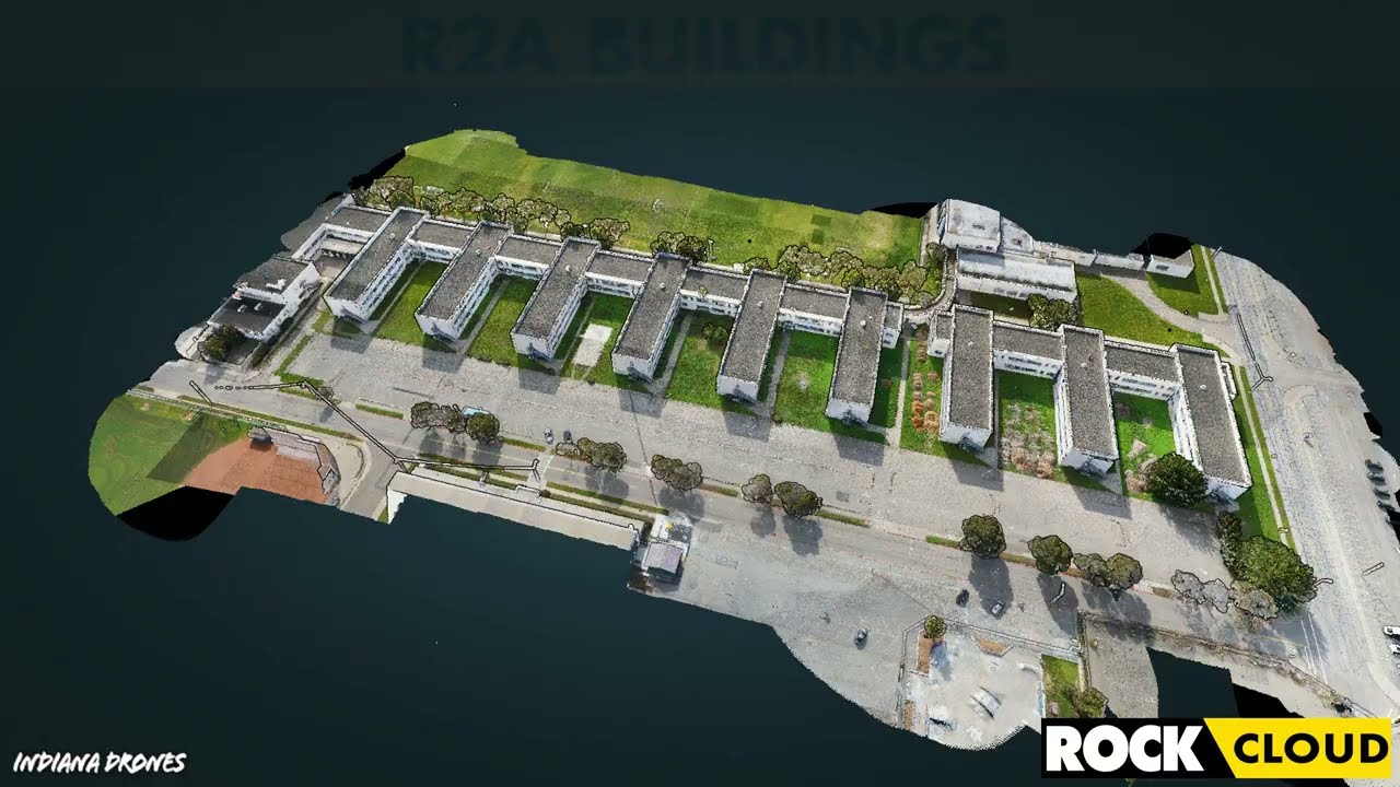
Featured Use Case: Surveying 750 Acres in Under 12 Hours with ROCK R2A LiDAR
At ROCK Robotic, we've been doing our best to spread the word that LiDAR is the game-changer in land surveying. Experienced drone pilot...
2 min read
414


IRS Section 179 Changes Coming: Why You Should Invest in LiDAR Equipment by the End of 2022
The Section 179 deduction allows US taxpayers to expense qualifying purchases and to deduct the full purchase price of their equipment.
2 min read
1,064


How-To Improve DJI Zenmuse L1 Accuracy w/ Strip Alignment in ROCK Cloud LiDAR Processing Software
Introducing ROCK Strip Alignment — offered exclusively through the ROCK Cloud to help improve the accuracy of your DJI L1 LiDAR data.
3 min read
1,842


Get 1.65 cm Accuracy Results with the ROCK R2A Drone LiDAR & ROCK Cloud 3D Data Processing Software
ROCK Robotic's R2A LiDAR with the ROCK Cloud processing software can produce 1.65 cm accuracy! Bold statement, I know. So, let me break...
5 min read
3,391


Capturing Aerial Drone LiDAR & Photogrammetry in a Single Flight (Earthworks Demo)
This article will discuss the results from the R2A LiDAR + Photogrammetry solution, alongside the output deliverables from the ROCK Cloud.
3 min read
2,259


Improving Accuracy of DJI Zenmuse L1 with ROCK Cloud 3D LiDAR Data Processing Software
Aerial Drone LiDAR has never been more accessible. The new wave of LiDAR hardware spans a large price and quality range. In order to address
4 min read
3,777
Turn your LiDAR data into stunning animations using the ROCK Cloud.
It just keeps getting better! We absolutely love this new Drone LiDAR 3D Mapped dataset. Now you can easily export videos of your LiDAR...
1 min read
699
bottom of page