top of page


Insanely Accurate LiDAR: The New ROCK R3 PRO
Get ready to experience the next level of accuracy and workflow with the new ROCK R3 Pro survey-grade LiDAR system!
2 min read
1,896


Easily convert LAS to LAZ and view your point cloud in the field with ROCK Desktop (Free Download!)
We’re excited to launch ROCK Desktop, a free point cloud converter and visualizer. It converts your LAS files to LAZ files...
3 min read
1,369


How to Use Drone LiDAR for Construction Site Development
Construction site development is a complex process that requires precise planning and execution. Every detail must be accounted for...
3 min read
2,065


Case Study: Drone Services Provider Navigates a 2,500-Acre Gold Mine Site in Fiji with ROCK LiDAR
Kahuto Pacific was hired by a Canadian mining company to provide topographic, aerial LiDAR for a 2,500-acre (1,000-hectare) property.
5 min read
1,939


Top 3 Drone LiDAR Project Pitfalls (and How to Avoid Them)
Over the course of consulting with drone LiDAR clients, we've noticed three major project pitfalls DSPs make.
3 min read
699


GCP Best Practices for Aerial Surveying Projects
Ground Control Points (GCPs) are a crucial part of aerial surveying. They help make sure the data collected is as precise as possible.
3 min read
893


Case Study: Construction Company Saves $300k by Updating Contours with ROCK Cloud
Here's the top-level takeaway: Companies and contractors can save a significant amount of money in Construction and Earthworks projects.
4 min read
560


Case Study: 25 Acres of LiDAR Data Captured (and Delivered) in Under 48 Hours
Do you ever find yourself in a time crunch? When it comes to last-second client projects, it's easy for panic to begin to settle in. But,...
3 min read
917


3 Types of Contours — Which Option is Best for your Surveying Project?
Nearly every land surveying project needs updated, accurate contours. Whether you’re moving dirt, pouring concrete or measuring terrain.
2 min read
556


7 Drone Surveying & 3D Mapping Industry Predictions & Trends for 2023
As the use of drones continues to increase in the fields of surveying and mapping, there are a few key trends that we expect to see in 2023.
3 min read
824


Top 10 LiDAR Support Questions: Answered by the ROCK Support Team
Ever wonder what questions the ROCK Support Team answers most often? Take a look at our most asked questions.
2 min read
283


Breaking Down 20 Common LiDAR and Surveying Terms
Here's a glossary of 20 of the most helpful LiDAR and surveying terms you need to know if you're starting to create 3D models and maps.
3 min read
561

10 Reasons Why ROCK Cloud is the Best LiDAR Data Processing Software
We're living in very exciting times! LiDAR data is growing in popularity with the advent of handheld SLAM systems. Notably, the Leica...
7 min read
872

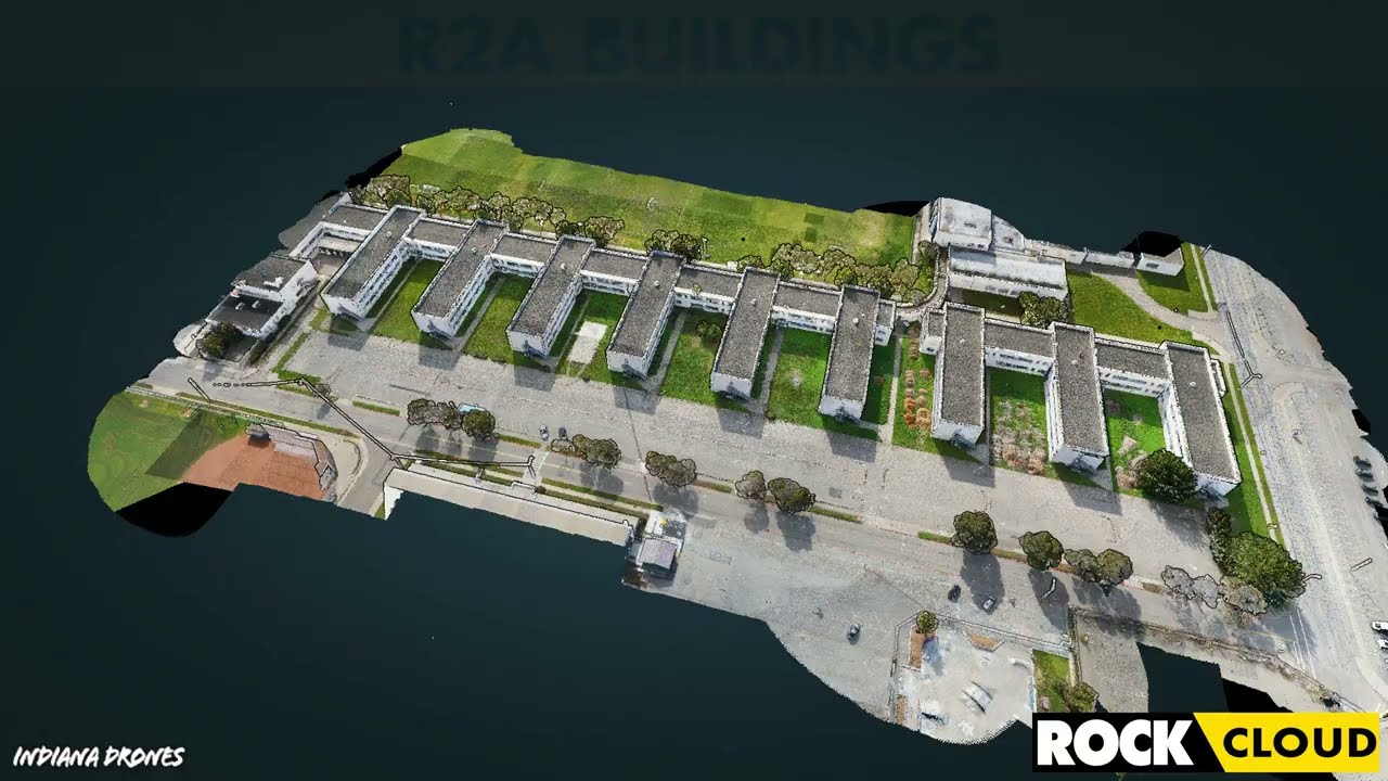
Featured Use Case: Surveying 750 Acres in Under 12 Hours with ROCK R2A LiDAR
At ROCK Robotic, we've been doing our best to spread the word that LiDAR is the game-changer in land surveying. Experienced drone pilot...
2 min read
414


How-To Improve DJI Zenmuse L1 Accuracy w/ Strip Alignment in ROCK Cloud LiDAR Processing Software
Introducing ROCK Strip Alignment — offered exclusively through the ROCK Cloud to help improve the accuracy of your DJI L1 LiDAR data.
3 min read
1,843


Get 1.65 cm Accuracy Results with the ROCK R2A Drone LiDAR & ROCK Cloud 3D Data Processing Software
ROCK Robotic's R2A LiDAR with the ROCK Cloud processing software can produce 1.65 cm accuracy! Bold statement, I know. So, let me break...
5 min read
3,392


Capturing Aerial Drone LiDAR & Photogrammetry in a Single Flight (Earthworks Demo)
This article will discuss the results from the R2A LiDAR + Photogrammetry solution, alongside the output deliverables from the ROCK Cloud.
3 min read
2,259


Improving Accuracy of DJI Zenmuse L1 with ROCK Cloud 3D LiDAR Data Processing Software
Aerial Drone LiDAR has never been more accessible. The new wave of LiDAR hardware spans a large price and quality range. In order to address
4 min read
3,777
Turn your LiDAR data into stunning animations using the ROCK Cloud.
It just keeps getting better! We absolutely love this new Drone LiDAR 3D Mapped dataset. Now you can easily export videos of your LiDAR...
1 min read
699
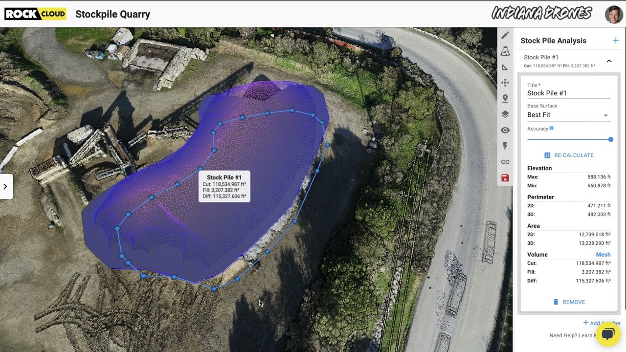
Easily calculate Volumetrics with the ROCK Cloud Stockpile Tool.
Good news... we have added a new feature to the ROCK Cloud! Now, you can quickly draw a polygon around an object to calculate the "Cut &...
1 min read
344
bottom of page