Most Affordable High-Quality Survey-Grade LiDAR
Complete R3 system with drone integration, professional software, and 1-year support. Everything you need to start collecting survey-grade data.
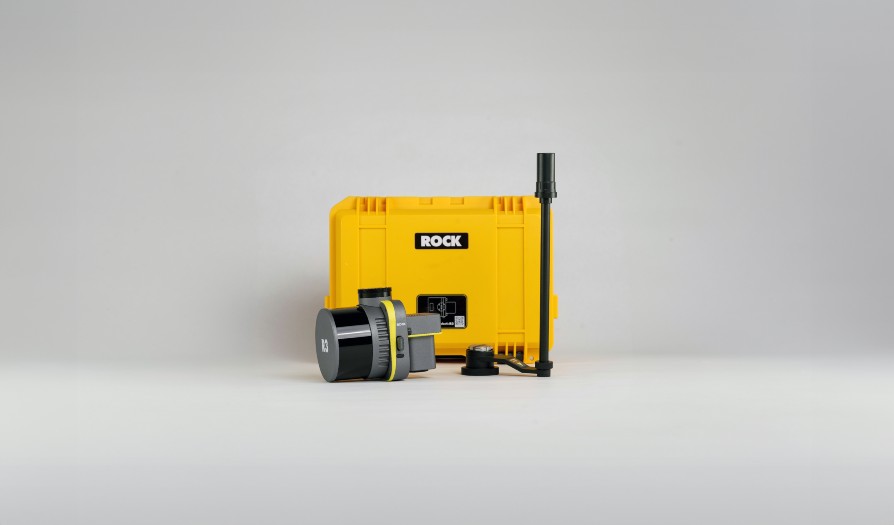
Complete Bundle Includes
- ROCK R3 V2 LiDAR System (640k pts/sec)
- M300/M350/M400 Integration Kit
- 26MP RGB Camera & Gimbal
- Professional Transport Case
Professional software suite
- 1 Year PPK Processing
- ROCK SLAM (GPS-denied scanning)
- ROCK Photogrammetry
- ROCK Cloud Access

Dear Survey Professional,
LiDAR shouldn't cost a fortune or require a PhD to operate. That's why we created the ROCK R3 Bundle—the most affordable path to professional survey-grade LiDAR data.
The R3 V2 gives you everything you need: 640k points per second, 2-3cm accuracy, and the flexibility to fly, drive, or walk your surveys. Mount it on your M300, M350, or M400 and start mapping immediately.
But here's what makes this special: it's not just hardware. You get our complete software ecosystem—PPK processing, SLAM capability, photogrammetry, and cloud storage—all included for the first year.
Whether you're a surveyor looking to add aerial capability, a drone operator wanting to offer LiDAR services, or an engineer needing accurate 3D data, the R3 Bundle is designed to get you profitable fast.
At $21,500, this bundle typically pays for itself in 2-3 projects. The time savings alone—mapping 50-100 acres in one flight instead of weeks on the ground—makes the ROI obvious.
This isn't just equipment. It's your competitive advantage. And my team will be with you every step of the way to ensure your success.
Ready to revolutionize your workflow,
Harrison Knoll
CEO, ROCK Robotic
P.S. This bundle price is for serious professionals ready to move fast. Book your demo call today.
Simple 4-Step Workflow
From data collection to finished deliverables—choose your own path with complete flexibility.
Collect Data with ROCK Pilot App
Launch missions with intelligent automation. ROCK Pilot handles calibration, monitors data quality in real-time, and ensures survey-grade accuracy on every flight.
- Automatic sensor calibration
- Real-time point cloud preview
- Terrain-following flight modes
ROCK Pilot App
Intelligent flight control for survey-grade data collection
Process with ROCK Desktop & Photogrammetry
Transform raw data into actionable results. Process LiDAR point clouds and create perfect orthomosaics with survey-grade accuracy—all in your office.
- PPK post-processing for survey accuracy
- LiDAR-driven photogrammetry (no distortion)
- Export to CAD, GIS, and industry formats
ROCK Desktop
Free processing software
Photogrammetry
Perfect orthomosaics
Your Choice: In-House or Cloud
Process everything yourself with ROCK Desktop, or optionally use our cloud services for additional capabilities.
Optionally: ROCK Cloud
OPTIONALStore, share, and collaborate on your data with advanced analytics and team management tools.
- Secure cloud storage & sharing
- Advanced analytics & reporting
- Team collaboration tools
Optionally: Pro Services
OPTIONALOrder professional CAD deliverables created by our expert team with AI-powered extraction and human QC.
- Topographic mapping & contours
- Planimetrics & feature extraction
- Volume calculations & analysis
Complete End-to-End Solution
Whether you process everything in-house or leverage our cloud and professional services, the R3 Bundle gives you everything you need to start delivering survey-grade results immediately.
Why the R3 is the Smart Choice
The most affordable high-quality survey-grade LiDAR available.
Entry-Level Price, Pro Results
At $21,500, the R3 delivers survey-grade accuracy at a fraction of the cost of competing systems. Perfect for getting started with professional LiDAR.
3-in-1 Versatility
One system that flies on drones, mounts on vehicles, or goes handheld. Aerial mapping today, mobile corridors tomorrow, indoor SLAM next week.
Complete Ecosystem
Hardware + software + training + support. Not just a sensor—a complete solution that gets you from raw data to finished deliverables.
3-in-1 Hardware Platform
One sensor, three mapping modes. Start with aerial and expand your capabilities as your business grows.
Included in Your R3 Bundle
Ready to fly out of the box
Aerial Mapping
INCLUDEDMount your R3 to M300, M350, or M400 drones for high-accuracy aerial surveys. Includes drone mount, gimbal integration, and all necessary cables.
- DJI drone integration
- Gimbal stabilization
- Real-time data monitoring
Basic SLAM
INCLUDEDBasic handheld SLAM capability for indoor mapping and GPS-denied environments. Perfect for getting started with indoor surveys.
- Handheld operation
- GPS-denied mapping
- Indoor scanning ready
Expand Your Capabilities
Add these optional accessories as your business grows
Mobile Mapping
Transform your vehicle into a mobile mapping platform. Add the ROCK Mobile Mount to capture corridors, roads, and large sites from ground level.
- Vehicle roof mounting
- Highway-speed mapping
- Corridor & infrastructure
Advanced SLAM
Upgrade to SLAM DOCK V2 for colorized point clouds, 360° photo spheres, and enhanced mobile mapping capabilities.
- Colorized point clouds
- 360° photo spheres
- Enhanced mobile SLAM
Grow with Your Business
Start with aerial mapping and basic SLAM, then expand to mobile mapping and advanced SLAM features as your projects demand. The R3 platform grows with you.
Choose Your Model
ROCK R3 V2
Perfect for aerial mapping
Complete bundle
- 16 laser channels, 640k pts/sec
- Aerial-optimized for drone mapping
- M300/M350/M400 Integration
- 2-3cm post-processed accuracy
- All software included (1 year)
ROCK R3 Pro V2
For high-density projects
Pro bundle
- 32 laser channels, 1.28M pts/sec
- Aerial + Mobile + SLAM ready
- 2x point density vs R3
- Better vegetation penetration
- All software included (1 year)
ROCK Ultra
Long-range specialist
Field-to-finish
- 1000m range, 1M pts/sec
- 1550nm eye-safe laser
- 7 returns per pulse
- Large-area mapping specialist
- All software included (1 year)
All bundles include hardware, software, training, and support. Financing available.
What You'll Need
Compatible Drones
- DJI Matrice 300 RTK
- DJI Matrice 350 RTK
- DJI Matrice 400New!
- Freefly Astro Max
- Inspired Flight 800
The R3 mounts directly to SkyPort 2.0 or compatible gimbals. Maximum takeoff weight stays well within limits.
Base Station (Recommended)
- ROCK Network RTK ServiceGlobal RTK corrections - $40/mo or $400/yr (Learn More)
- EMLID Reach RS3 for PPK processingPhysical base station (Learn More)
- Existing base station with RINEX outputUse your current setup
Note: You can start mapping immediately without a base station using relative accuracy. Add PPK later for survey-grade absolute accuracy.
30-Day Success Guarantee
R3 Success Stories
See how professionals are using the R3 to grow their business.
"The R3 paid for itself in two months. I can now offer aerial surveys to all my clients and the accuracy rivals traditional methods."
"Adding LiDAR with the R3 tripled my revenue per flight. Clients love the detailed 3D data and fast turnaround."
"The 3-in-1 capability is amazing. We map sites by air, then use mobile mode for road corridors. One system, complete coverage."
"SLAM mode lets us map under canopy where GPS fails. The vegetation analysis tools are incredibly detailed."
"Weekly progress monitoring is so easy now. Fly the site in 20 minutes, have volume calculations the same day."
"Stockpile volumes, pit surveys, haul road mapping—the R3 handles all our surveying needs safely from the air."
Frequently Asked Questions
Is the R3 really survey-grade accurate?
Yes. With proper PPK processing, the R3 achieves 2-3cm absolute accuracy—suitable for topographic surveys, ALTA surveys, and construction monitoring. We include calibration certificates and test data with every system.
How fast can I see ROI?
Most customers recover their investment in 2-4 projects. A typical 50-acre topographic survey that would take a crew weeks can be completed in one flight and processed the same day, at 30-50% higher margins.
What if I need more point density?
The R3 Pro V2 offers double the point density (1.28M vs 640k pts/sec) with 32 laser channels. You can always upgrade later, and we offer trade-in credit for R3 customers.
Is training really included?
Yes. You get ROCK Academy access (48 modules), live onboarding sessions, and direct support. Most users are flying confidently within the first week.
Can I finance the purchase?
Yes, we work with several financing partners to offer flexible payment options. Many customers qualify for equipment financing with competitive rates.
Ready to Get Started?
Book a personalized demo to see how the R3 Bundle fits your specific needs. We\'ll show you real project data and discuss your workflow.
Sales: +1 (720) 706‑8648 · sales@rockrobotic.com
Bundle Includes Everything
We ensure you achieve survey-grade results
Learn More
Latest Insights & Guides
Explore our latest articles on LiDAR mapping, surveying best practices, and industry insights

Jul 31, 2025
UAV‑Based LiDAR and the Importance of Flight Trajectory
Introduction Unmanned‑aircraft (UAV) laser‑scanning systems combine a lidar sensor with a global navigation satellite system (GNSS)...
Dec 26, 2024
R3 V2 Van Bibber Creek
Showing off the R3 Vegetation Penetration.

Dec 19, 2023
Mastering Drone LiDAR Scanning with ROCK R3 Pro & DJI M300
Explore the process of flying the R3 Pro LiDAR scanner to map buildings using the DJI M300 drone.
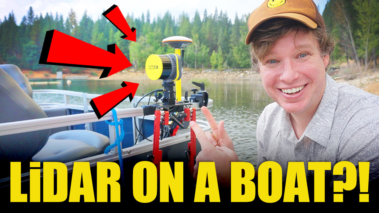
Oct 24, 2023
Navigating Waters & 3D Data: Mobile Mapping on a Boat with the ROCK R3 Pro LiDAR
LiDAR Mobile Mapping on a Boat with the ROCK R3 Pro
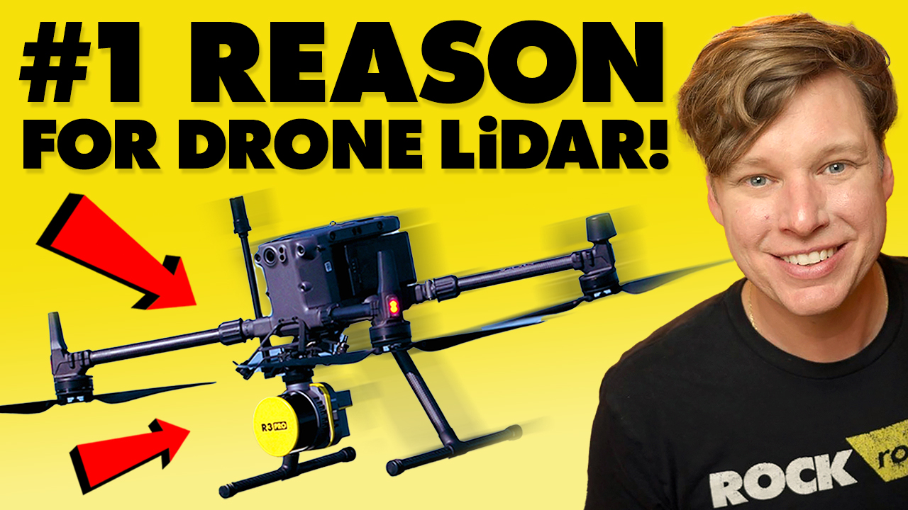
Oct 9, 2023
Vegetation Penetration: The #1 Reason for Drone LiDAR
Explore how the ROCK R3 Pro LiDAR system overcomes the challenge of dense vegetation in land surveying.
Sep 20, 2023
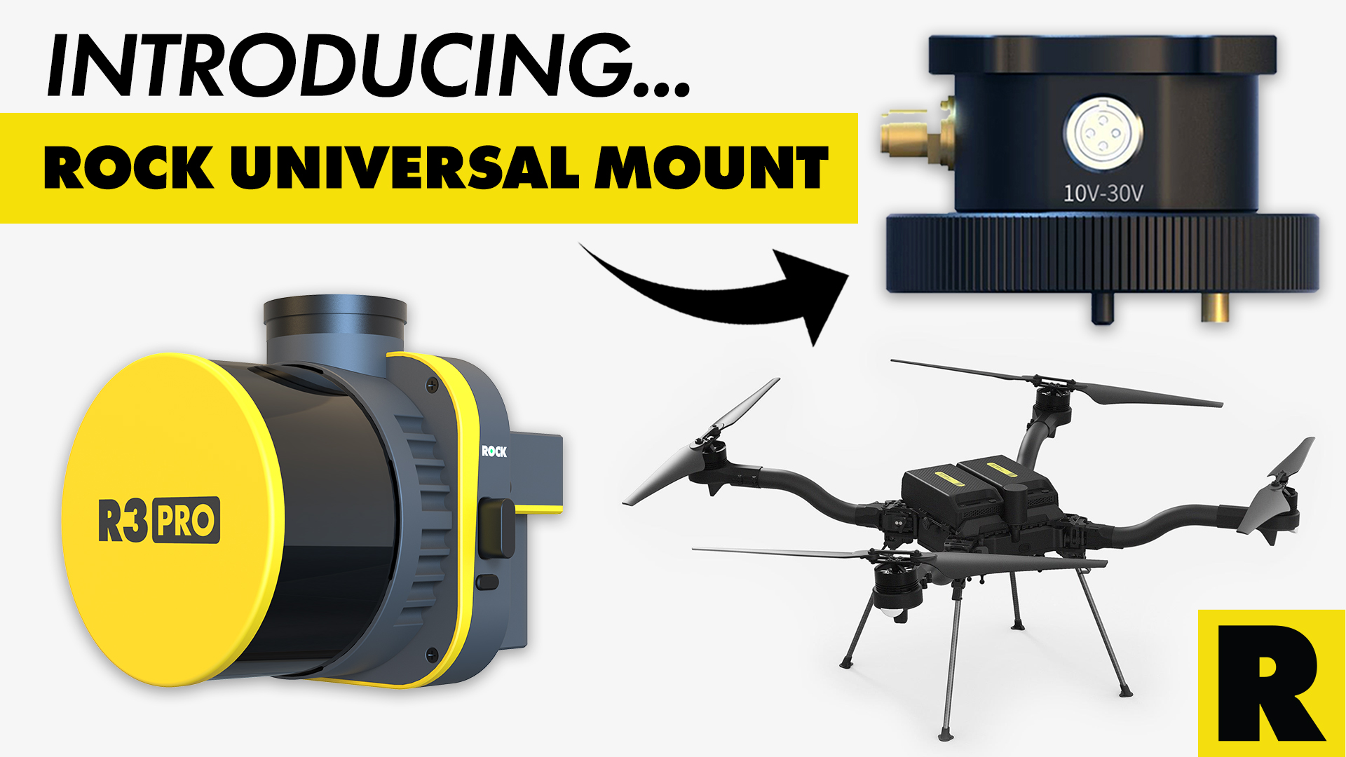
Unlocking Drone Compatibility: ROCK Robotic's Universal Mount for the R3 Pro LiDAR
The ROCK R3 Pro LiDAR is now compatible with any drone!
Sep 14, 2023
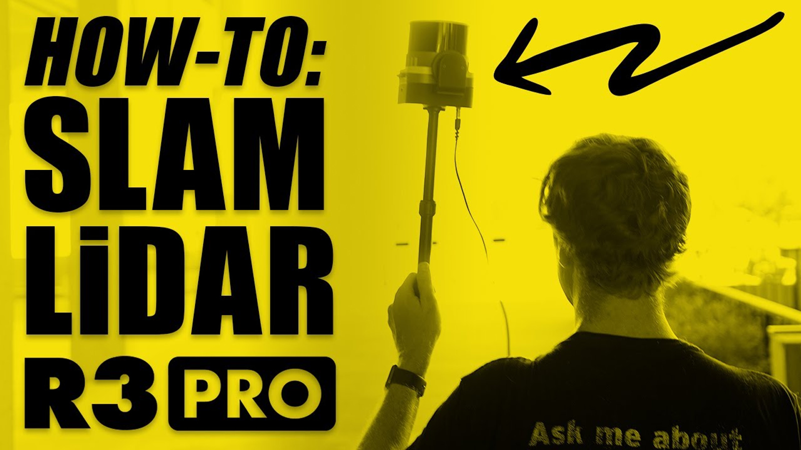
ROCK SLAM LiDAR with the R3 Pro: A Comprehensive Guide
In this article, we'll delve into how to operate the R3 Pro with SLAM mode and share some valuable tips on capturing high-quality data.
Aug 4, 2023
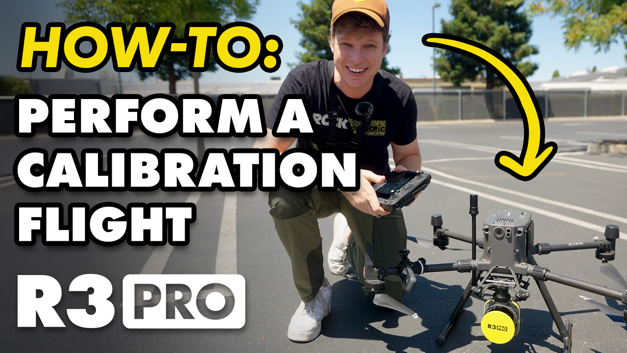
How-To Perform Calibration Flight for ROCK R3 Pro, R360, & R2A
In this informative guide, we'll walk you through the step-by-step process to ensure precise and accurate data collection every time.
Start Collecting Survey-Grade Data Today
Join hundreds of professionals who trust the ROCK R3 for their most important projects.